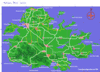
MAP OF ANTIGUA BY AREA AND MAP OF ANTIGUA ISLAND
Our Antigua map section - You can navigate around Antigua and St. John's by clicking on any of the sections of the navigation maps to the right or scroll down and open the google map to discover where businesses, beaches and places to visit are located. Where is Antigua? It's one of a chain of islands, which form part of the Leeward Islands in the Eastern Caribbean.
ANTIGUA MAP
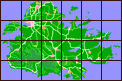
The map of Antigua is split into 24 sections across the entire island, allowing you to look at smaller sections of the island in more detail. To make searching in a general area a little easier we have also assigned each map location to a regio. The island is splitup as follows:
|
MAP
|
AREA
|
REGION
|
|
|
North West Ocean
|
North West
|
|
|
Dickenson Bay & Blue Waters
|
North West
|
|
|
Hodges Bay & the Airport
|
North West
|
|
|
Long Island & Maiden Island
|
North
|
|
|
North Sound
|
East
|
|
|
North East Ocean
|
East
|
|
|
Five Islands
|
North West
|
|
|
St. Johns
|
St. John’s
|
|
|
Factory Road, Piggots & Potters
|
Interior
|
|
|
Parham & Pares
|
North
|
|
|
Seatons & North Sound
|
East
|
|
|
Long Bay
|
East
|
|
|
Jolly Harbour
|
West
|
|
|
Jennings & Ebenezer
|
Interior
|
|
|
Fig Tree Drive & Buckleys
|
Interior
|
|
|
Potworks Dam and Bethesda
|
Interior
|
|
|
St. Phillips
|
East
|
|
|
Nonsuch Bay & Green Island
|
East
|
|
|
Crab Hill & Johnsons Point
|
West
|
|
|
Cades Bay & Old Road
|
South
|
|
|
Rendezvous Bay & Turtle Bay
|
South/South East
|
|
|
Falmouth & English Harbour
|
South/South East
|
|
|
Willoughby Bay & Mamora Bay
|
South/South East
|
|
|
Half Moon Bay & Soldier Point
|
East
|
|
|
Barbuda
|
Barbuda
|
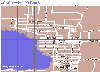
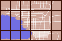
ST. JOHN'S MAP
The map of St. John's, the capital city of Antigua, is also sectioned into 24 separate areas. Click on the individual links to the right to check out listings in each area.
|